Wednesday, August 25, 2010
Trail running sites
Purpose: Accurate trail maps and information. Sometimes great for trail conditions as well.
Properties: Digital. Many of these sites have GPS coordinates, or just print out the maps. Use waterproof paper if you want something durable.
For accurate, up-to-date trail information, I have found trail runners and their websites to be particularly helpful. After hiking a trail I came across on a drive, the only information I could find about it was one of these sites. None of my maps showed anything about it as well, despite the fact that it had official (looking, at least) trail signs and linked up to maintained parking areas.
Here are two I use:
Timp Trail Running
RunUtah.net
Tuesday, August 24, 2010
Wasatch Front Panoramic Hiking Map
Publisher: Trail Tracks
Price: $12
Purchase: trailtracks.com (not sure the store I picked it up at)
Purpose: Not the most useful map for taking out on the trail, but the unique view angle gives useful elevation information quickly that is hard to get from other maps.
Properties: Waterproof, tear resistant, trail information (distance, elevation gain, difficulty) on the front, additional trails and general information ("Human sexual activity attracts bears") on the back.
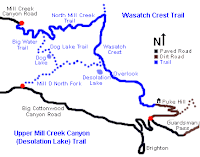
Although this is a fun map to just look at, the look is also useful in ways that hard to describe. I just know that when I am describing where I went over the weekend to someone, I like to use this map. For example, the Wasatch Crest trail on Utah Mountain Biking shows this map, which is the one I take out with me:
On the panoramic map, the trail looks like this:
Subscribe to:
Comments (Atom)


