Tuesday, August 24, 2010
Wasatch Front Panoramic Hiking Map
Publisher: Trail Tracks
Price: $12
Purchase: trailtracks.com (not sure the store I picked it up at)
Purpose: Not the most useful map for taking out on the trail, but the unique view angle gives useful elevation information quickly that is hard to get from other maps.
Properties: Waterproof, tear resistant, trail information (distance, elevation gain, difficulty) on the front, additional trails and general information ("Human sexual activity attracts bears") on the back.
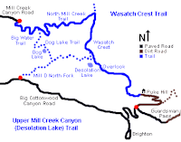
Although this is a fun map to just look at, the look is also useful in ways that hard to describe. I just know that when I am describing where I went over the weekend to someone, I like to use this map. For example, the Wasatch Crest trail on Utah Mountain Biking shows this map, which is the one I take out with me:
On the panoramic map, the trail looks like this:
Subscribe to:
Post Comments (Atom)


No comments:
Post a Comment